Plan de marche
Prenons un exemple
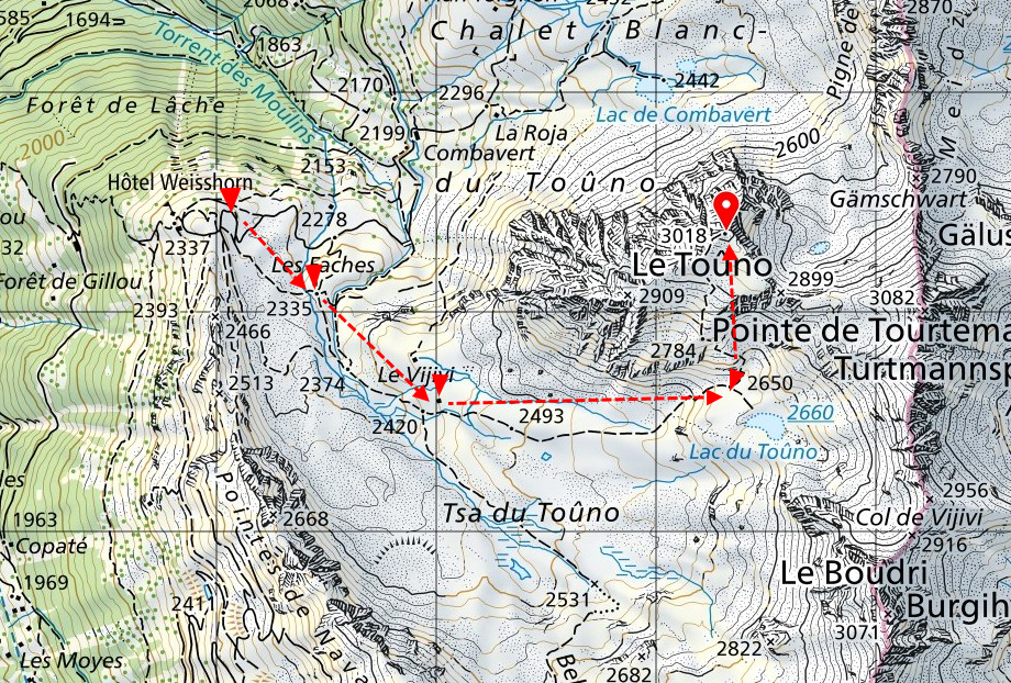
Vous devez vous rendre de l’hôtel Weisshorn au sommet du Toûno (Val d’Anniviers, Suisse).
On visualise d’abord l’itinéraire sur la carte puis on établi le plan de marche correspondant
Départ Hôtel Weisshorn, puis Les Faches – Le Vijivi – Lac du Toûno
et enfin le sommet du Toûno

Plan de marche
| Lieu | Altitude | Azimut | Dénivelé | Distance | Temps |
| Hôtel Weisshorn | 2337 | … | … | … | … |
| Les Faches | 2340 | 118 | 3 | 800 | 10 |
| Vijivi | 2442 | 123 | 102 | 600 | 20 |
| Lac | 2659 | 100 | 217 | 1700 | 46 |
| Toûno | 3017 | 352 | 358 | 1000 | 74 |
Pour calculer le temps de marche, additionner la distance parcourue (en kilomètres) au dénivelé (en hectomètres), le tout multiplié par un indice fonction de la difficulté. Le résultat donne le temps en minutes.
La formule pour calculer le temps de marche
(distance (km) + dénivellation (hm)) x indice = temps (minutes)
Calculons donc le temps de marche pour monter de l’hôtel Weisshorn au sommet du Toûno. De l’hôtel au lac, distance 3.1 km, dénivelé 320 m, sentier sac léger (indice 12). Du lac au sommet, distance 1 km, dénivelé 360 m, pierriers (indice 16).
- Hôtel – Lac: (3.10 + 3.20) x 12 = 76 minutes
- Lac – Toûno: (1.00 + 3.60) x 16 = 74 minutes
- Total: 76 + 74 = 150 minutes soit 2h50
Les indices en fonction des difficultés (a)
| Difficulté | Montée | Descente |
| Sentier, sac léger | 12 | 8 |
| Sentier, sac lourd | 14 | 9 |
| Pierrier | 16 | 6 |
| Blocs de rocher | 20 | 19 |
(A) Ces indices sont donnés à titre indicatif. Ils sont modifiables en fonction des expériences individuelles.
Azimut de retour
Pour revenir sur ses pas, il faut savoir calculer l’azimut de retour (contre azimut). Pour le calculer, il suffit d’ajouter 180° (si l’azimut est inférieur à 180°), ou retrancher 180° (si l’azimut excède 180°).
Exemples: Contre azimut de 60° = 60 + 180 = 240°. Contre azimut de 310° = 310 – 180 = 130°
Le meilleur moyen pour acquérir les connaissances nécessaires est de suivre un cours pratique d’orientation.
De nombreux sites offrent la possibilité d’acquérir une formation théorique. Parmi ceux-ci, le site du CAS.
Autres outils et moyens
Il est très frustrant de se lever tôt, de trimballer un sac lourd, et d’avoir des ampoules aux pieds, pour se retrouver au milieu de nulle part… et pas sur le sommet convoité.
Pour éviter ces déboires, en plus des cartes, il est judicieux de se référer à d’autres sources telles que les topo-guides (exemple Valais), les récits de course, les photos. Ne pas hésiter à demander des renseignements au gardien.
Un carnet et un crayon dans le sac pourront souvent être utiles.
Vidéo sur l’orientation
Sites sur l’orientation
Route planner
Let’s take an example
You need to get from the Hotel Weisshorn to the summit of Toûno (Val d’Anniviers, Switzerland).
First, you visualise the route on the map and then draw up the corresponding walking plan.
Departure from Hôtel Weisshorn, then Les Faches – Le Vijivi – Lac du Toûno and finally the summit of Toûno

Route planner
| Location | Altitude | Azimut | Vertical rise | Distance | Time |
| Hôtel Weisshorn | 2337 | … | … | … | … |
| Les Faches | 2340 | 118 | 3 | 800 | 10 |
| Vijivi | 2442 | 123 | 102 | 600 | 20 |
| Lac | 2659 | 100 | 217 | 1700 | 46 |
| Toûno | 3017 | 352 | 358 | 1000 | 74 |
To calculate the walking time, add the distance covered (in kilometres) to the difference in altitude (in hectometres), multiplied by an index based on the difficulty. The result is the time in minutes.
The formula for calculating walking time
(distance (km) + difference in altitude (hm)) x index = time (minutes)
Let’s calculate the walking time from the Hotel Weisshorn to the summit of Toûno. From the hotel to the lake, distance 3.1 km, difference in altitude 320 m, light rucksack trail (index 12). From the lake to the summit, distance 1 km, altitude difference 360 m, scree (index 16).
- Hôtel – Lac: (3.10 + 3.20) x 12 = 76 minutes
- Lac – Toûno: (1.00 + 3.60) x 16 = 74 minutes
- Total: 76 + 74 = 150 minutes soit 2h50
Indices according to difficulties (a)
| Difficulty | Ascent | Descent |
| Trail, light bag | 12 | 8 |
| Trail, heavy bag | 14 | 9 |
| Stones | 16 | 6 |
| Boulders | 20 | 19 |
(a) These indices are given for guidance only. They may be modified according to individual experience.
Return azimuth
To retrace your steps, you need to know how to calculate the return azimuth (counter-azimuth). To calculate this, simply add 180° (if the azimuth is less than 180°), or subtract 180° (if the azimuth exceeds 180°).
Here are some examples: Counter azimuth of 60° = 60 + 180 = 240°. Counter azimuth of 310° = 310 – 180 = 130°.
The best way to acquire the necessary knowledge is to take a practical orientation course.
A number of sites offer the opportunity to acquire theoretical training. These include the CAS website.
Other tools and resources
It’s very frustrating to get up early, carry a heavy rucksack and have blisters on your feet, only to find yourself in the middle of nowhere… and not on the summit you’re aiming for.
To avoid these pitfalls, in addition to maps, it’s a good idea to refer to other sources such as topographical guides (e.g. Valais), race reports and photos. Don’t hesitate to ask the warden for information.
A notebook and pencil in your bag will often come in handy.


0 commentaires